Slider

slide1

Drone Structure Scan - Derelict Cottage

Detailed 3D model of and old derelict cottage in Midvale.

slide2

Small Drone Mapping 101

The Aero Scout shares his experiences with drone mapping and 3D models.

slide3

Arthur River Mt Pleasant Kitchen - 3D drone structure scan

3D model of the heritage building Mt Pleasant Kitchen in Arthur River.

slide4

Chestnut Brae - Farm planning map in Nannup

Demonstrating how drone imagery can be used as a base for effective farm planning.

slide5

Drone Structure Scan - Heritage Lighthouse

Drone structure scan of the heritage South Mole Lighthouse in Fremantle.

Golden Pipeline - 3D Scan Inspection

Pipeline Inspection

Mission Summary

  • Goal:  Determine of drone imagery is effective for pipeline inspection purposes
  • Tech: DJI Phantom 3 4K, Drone Deploy
  • Conditions: Early Afternoon and sunny
  • Outcome: Drone imagery enables quick and accurate analysis and it also shows the larger field-scale trends that can go unseen at ground level 

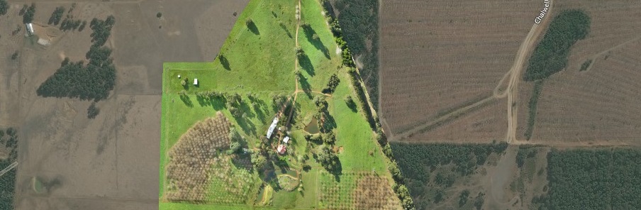
It was a gorgeous winter day so we packed the family up (along with a thermos and tea) and headed east to the fringes of the wheat belt with the aim of finding an un-shaded length of the iconic Golden Pipeline to scan. I have previously had two failed attempts of scanning the pipeline, both of these done closer to the city and in areas with far more tree cover.


This has been another 'drone adventure' in aerial surveying, inspection and mapping by The Aero Scout.


Homestead - 3D Scan

3D house scan

Mission Summary

  • Goal:  A
  • Tech: B
  • Conditions: Early Afternoon and sunny
  • Outcome: Drone 

It was a


This has been another 'drone adventure' in aerial surveying, inspection and mapping by The Aero Scout.