Slider

slide1

Drone Structure Scan - Derelict Cottage

Detailed 3D model of and old derelict cottage in Midvale.

slide2

Small Drone Mapping 101

The Aero Scout shares his experiences with drone mapping and 3D models.

slide3

Arthur River Mt Pleasant Kitchen - 3D drone structure scan

3D model of the heritage building Mt Pleasant Kitchen in Arthur River.

slide4

Chestnut Brae - Farm planning map in Nannup

Demonstrating how drone imagery can be used as a base for effective farm planning.

slide5

Drone Structure Scan - Heritage Lighthouse

Drone structure scan of the heritage South Mole Lighthouse in Fremantle.

Showing posts with label UAV Structure Scan. Show all posts

Chestnut Homestead

Drone Structure Scan - Chestnut Homestead

Drone Structure Scan of a multiple buildings and structures of interest at a farm homestead in Nannup using a Mavic Pro and processing with Agisoft Metashape.

Mission Summary

  • Goal: To scan multiple structures at the same time
  • Tech: DJI Mavic Pro, Agisoft Metashape
  • Conditions: Midday, overcast/rainy, light wind
  • Outcome: Using a combination of nadir, angle and point of interest scanning techniques I was successful in creating a good model of the homestead with it's multiple structures and highlights


This has been another 'drone adventure' in aerial surveying, inspection and mapping by The Aero Scout.


Nannup Tank #7

Drone Structure Scan - Water Tank

Drone Structure Scan of a forestry water tank in Nannup using a DJI Spark and processing with Agisoft Metashape.

Mission Summary

  • Goal: We arrived at a lookout for a family picnic and I just had to drone scan it, even though it was blowing an absolute gale! (legit drone pilot term)
  • Tech: DJI Mavic Pro, Drone Deploy
  • Conditions: Midday, stormy, extreme wind
  • Outcome: The little DJI Spark did an amazing job in extreme conditions to capture not only the tank but it's surrounds  
Tank 7 is one of a number of concrete tanks which dot the hills around Nannup and were once used to supply water to crews fighting fires in the area. The views over Nannup and surrounds are spectacular. Mountain bikers, hikers and picnic goers all enjoy from it's delights.


This has been another 'drone adventure' in aerial surveying, inspection and mapping by The Aero Scout.


Derelict Chicken Treat

Drone Structure Scan - Derelict Chicken Treat

Drone Structure Scan of a derelict fast food building in Midvale, Perth using a Mavic Pro and processing with Metashape.

Mission Summary

  • Goal: To recreate an accurate model of a bulkhead roof structure with multiple vertical faces and thin edges
  • Tech: DJI Mavic Pro, Agisoft Metashape
  • Conditions: Midday, stormy and windy
  • Outcome: A detailed model was created, I just need to improve of the fidelity around the eaves and 'under surfaces'.
I thought I would continue my 'derelict' themed scanning for this month. When I was in my 20's I used to visit this fast food establishment, there actually used to be a movie cinema and a food hall on the same site, all gone now.

The fascination with this site was the vertical faces and re-creating a great model of them, also a tree close by and a barbed wire fence containing the subject all add up to a flying challenge I was keen for.
Robust and versatile, the good ole Mavic Pro is still an excellent scanning drone, even in stormy and windy conditions 

The deep vertical faces on the inside of the roof structure  

Using both an outside-in orbit plus and inside-out circle was key to achieving good detail on the roof
The detail of the inside vertical faces of the roof bulkhead and the mechanical equipment has been capture well 

The screen wall for the service area at the rear of the building was also re-created to a good level of detail. The 'bubbling'around the top of the wall is where the rings of razor wire are, unfortunately the processing couldn't generate a solid from it

Achieving a crisp recreation of the eaves is always a challenge. The Mavic Pro has a small ángle up' feature for the camera however in this case the barbed wire fence enclosed the flight path too much and getting a good angle on the eaves almost impossible. You can also see in the lower centre-right of the image some the perimeter fence that was not well modelled.

The detail for the roof is so good that it is clear it could really do with a clean of it's gutters. :)
Enjoy the orbit of the finished 3D model or click in the screen below to explore it in more depth. Processing was achieved using a medium quality setting in Agisoft Metashape on my laptop.


This has been another 'drone adventure' in aerial surveying, inspection and mapping by The Aero Scout.

Derelict Cottage


Drone Structure Scan - Derelict Cottage

Drone Structure Scan of an old derelict cottage in Midvale, Perth using a tiny DJI Spark drone and processing with Metashape.

Mission Summary

  • Goal: To create a better result (compared to previous scans) for framed structures from drone scanning and photogrammetry
  • Tech: DJI Spark, Agisoft Metashape
  • Conditions: Afternoon, stormy and windy
  • Outcome: Using a combination of proximity manual flying and multiple sweeps, this is one of the best reconstructions of a framed structure that I have completed, albiet that I could only process using a medium quality setting.
A detailed 3D model of a derelict cottage created from drone images. The roof framing, broken panels and missing sheeting all contribute to a complex and difficult model to create. Having a good awareness of the software's needs plus clever flying techniques are critical for success.  
Obtaining a good drone scan of a structure with multiple framing members has always been a challenge for me. The software requires photos from every angle, however usually a drone scan only encompasses and external orbit or two plus a naidar plan.

Driving along the highway I noticed this cottage that looked like it would make a great case study and would assist in developing my skills. It was a great site, far enough back from the road not to be a danger to vehicles passing and no high obstructions to hinder the drone either.

In order to capture images from as many different angles as possible required manually flying this mission. Usually I start by conducting a naidar flight path to give a good boundary to the project, then one, two or maybe three orbits. This time in addition to those, I also thought about how I could capture more details on the roof framing and took the DJI Spark into some proximity flying to highlight those areas.

Unfortunately, for the model, I have to run the Metashape processing on medium quality as my laptop can't handle anything higher. Even on medium it still took 3 days to progress through the processing steps of image alignment, building the dense cloud, creating the mesh and applying the texture. In the future I hope to give more justice to the model by being able to increase the processing quality settings.  

For a mission like this, manual proximity flying and creative flight angles are key to success 
It can be seen from these images below of the model that the roof timbers have been reconstructed quite accurately (taking into account that the processes settings where set to medium quality). Whilst I did not capture images from below the roof timbers, top and all sides have been covered.

From this closer view, the complexity of the model can easily been seen

Roof timbers, whilst not perfect, have been recreated with a good level of representation
Having even light across the entire project is difficult, especially in sunny Perth. High contracting, dark shadows can really affect the outcome of a scan. On this day it was stormy and cloudy, which means that we have lovely diffused light, no hard shadows on the south side of the model. The trick was dodging the storms and rain showers, but again in Perth, that's not an all day affair.

A cloudy day assists in creating an even texture to the model, especially on the south side of the structure 

Enjoy the orbit of the finished 3D model or click in the screen below to explore it in more depth.


This has been another 'drone adventure' in aerial surveying, inspection and mapping by The Aero Scout.

Point King Albany WW II Observation Post


Point King, Albany WW II Observation Post Drone Scan with Drone Deploy
Drone scan of  an un-named WWII observation post near Point King, Albany, Western Australia

Drone Structure Scan - Historical Landmark

Drone Structure Scan of a WW II Observation Post at Point King, Albany using a Mavic Pro and photogrammetry processing with Drone Deploy.

Mission Summary

  • Goal: To create a highly detailed drone structure scan of a WWII observation post that reminded me of the Autodesk Recap video of Battery Townley near San Francisco.
  • Tech: DJI Mavic Pro, Drone Deploy
  • Conditions: Midday, sunny, very windy
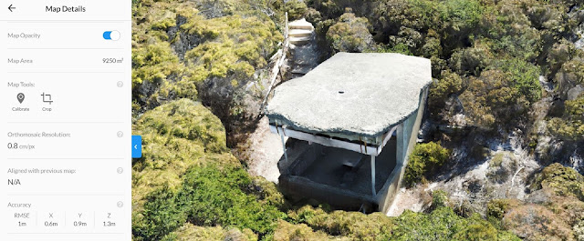
  • Outcome: This ended up being my most detailed map to date. See above the 'map details'  show a resolution of 0.8cm/px and an RMSE of 1m. This was accomplished with a fully manual flight (no automated flight plan), in very windy conditions and using a Mavic Pro with a 12Mp camera. I'm impressed and super proud. :)
Point King, Albany WW II Observation Post - Drone Scan Image-1
The entire site, flown very carefully manually with the camera set to take a photo every 2sec

Point King, Albany WW II Observation Post - Drone Scan Image-2
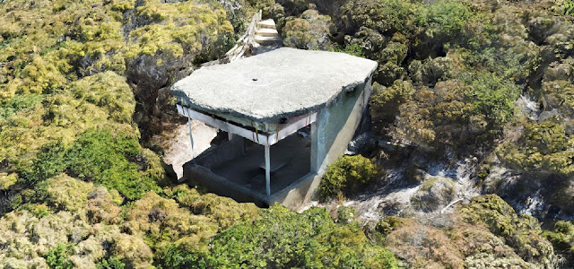
A glimpse of the old WWII concrete structure just visible amongst the thick coastal scrub

Point King, Albany WW II Observation Post - Drone Scan Image-3
The roof of the structure was created in a 'ragged' form to make it look like a rock

Point King, Albany WW II Observation Post - Drone Scan Image-4
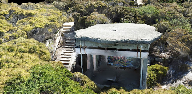
The detail of the structure scan created by Drone Deploy was excellent, this is my best scan to date

Point King, Albany WW II Observation Post - Drone Scan Image-5
A detailed look inside the structure, this was made possible by the upward camera option on the DJI Mavic Pro

Point King, Albany WW II Observation Post - Drone Scan Image-6
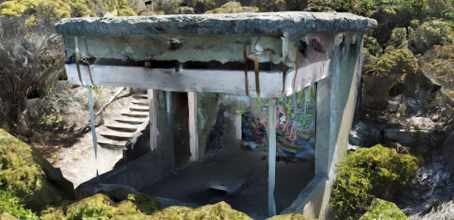
Flying the DJI Mavic Pro manually and very close to the structure meant I could capture detailed photos of it's interior 

Point King, Albany WW II Observation Post - Drone Scan Image-7
Using the upward camera feature of the DJI Mavic Pro I managed to capture all of the inside of the structure, including it's soffit
Point King, Albany WW II Observation Post - Drone Scan Image-8
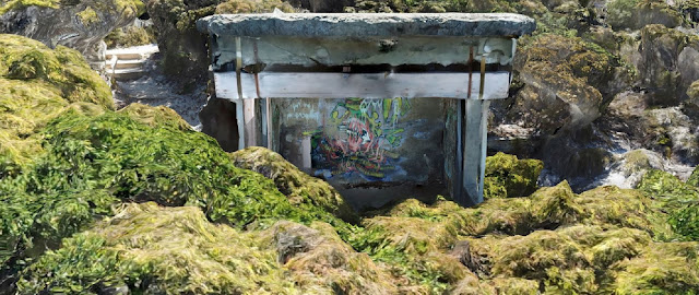
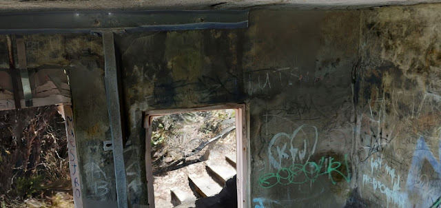
Some of the graffiti tags over the structure

Point King, Albany WW II Observation Post - Drone Scan Image-9
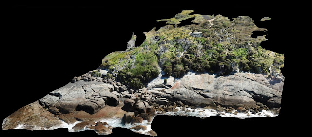
Elevation gradient of the site, clearly showing the rocks, dense scrub and access to the structure
Drone Deploy Logo

A link to the Autodesk video that inspired it all;  From GoPro photos to a conceptual model in Revit. In 2014, when I watched this video I was hooked, it gave me the initial spark and motivation that got me interested in drone scanning and Scan-To-BIM technology and methodologies. Since then it has been both a passion and addiction to drone-scan nearly everything that I see.

If you liked this post, check out another similar post on a scan I did on the same road trip, it's of the Arthur River Mt Pleasant Kitchen heritage cottage.

This has been another 'drone adventure' in aerial surveying, inspection and mapping by The Aero Scout.

Arthur River Mt Pleasant Kitchen Cottage

Arthur River Mt Pleasant Kitchen Drone Scan with Drone Deploy - Image 1
Drone scan of the Arthur River Mt Pleasant Kitchen built in 1869 to cater for travellers, sandalwood cutters and settlers

Drone Structure Scan - Heritage Cottage

Drone Structure Scan of the heritage building Mt Pleasant Kitchen in Arthur River, Western Australia using a Mavic Pro and photogrammetry processing with Drone Deploy.

Mission Summary

  • Goal: To drone scan a heritage cottage and capture the details under the veranda
  • Tech: DJI Mavic Pro, Drone Deploy
  • Conditions: Midday, sunny, moderate wind, extremely hot (45 degrees celcius)
  • Outcome: On a stinking hot day I used three/four orbit rings plus some handheld pics under the veranda to create one of my best scans yet. The detail under the veranda and the eaves would not have possible without the 'camera angled up' feature on the Mavic Pro.  

Arthur River Mt Pleasant Kitchen Drone Scan with Drone Deploy - Image 2
The stats from Drone Deploy show the resolution and accuracy of the scan

Arthur River Mt Pleasant Kitchen Drone Scan with Drone Deploy - Image 3
Even the plants are looking great in the scan. Also see the accuracy under the veranda 

Arthur River Mt Pleasant Kitchen Drone Scan with Drone Deploy - Image 4
This image shows the level of detail captured under the veranda

Arthur River Mt Pleasant Kitchen Drone Scan with Drone Deploy - Image 5
Beautiful stonework captured in a virtual 3D model

Arthur River Mt Pleasant Kitchen Drone Scan with Drone Deploy - Image 6
The textures in the model are great and the detail in the sign creates a real point of interest
Drone Deploy Logo

If you liked this post, check out another similar post on a scan I did on the same road trip, it's of the Point King Albany WWII Observation Post.

This has been another 'drone adventure' in aerial surveying, inspection and mapping by The Aero Scout.

West Kulin Tin Horse Highway

West Kulin Tin Horse Highway Drone Scan using Drone Deploy - Image 1
3D drone scan of the West Kulin Whoppa tin horse

Drone Structure Scan - Tin Horse

A drone structure scan of part of the West Kulin Tin Horse Highway using a Mavic Pro and photogrammetry processing with Drone Deploy.

Mission Summary

  • Goal: To drone scan a couple of the famous Kulin tin horses.
  • Tech: DJI Mavic Pro, Drone Deploy
  • Conditions: Late afternoon, sunny, moderate wind
West Kulin Tin Horse Highway Drone Scan using Drone Deploy - Image 2
3D drone scan of one of the West Kulin Tin Horses
Drone Deploy Logo

This has been another 'drone adventure' in aerial surveying, inspection and mapping by The Aero Scout.