Slider

slide1

Drone Structure Scan - Derelict Cottage

Detailed 3D model of and old derelict cottage in Midvale.

slide2

Small Drone Mapping 101

The Aero Scout shares his experiences with drone mapping and 3D models.

slide3

Arthur River Mt Pleasant Kitchen - 3D drone structure scan

3D model of the heritage building Mt Pleasant Kitchen in Arthur River.

slide4

Chestnut Brae - Farm planning map in Nannup

Demonstrating how drone imagery can be used as a base for effective farm planning.

slide5

Drone Structure Scan - Heritage Lighthouse

Drone structure scan of the heritage South Mole Lighthouse in Fremantle.

Showing posts with label UAV 3D Mapping. Show all posts

Contours for Civil Design

3D model of site - The area that needs to be surveyed is the field just below the circular storage units

Mission Summary

  • Goal: Use drone scanning to create contours to assist in the design of an emergency hardstand.
  • Tech: DJI Phantom 4 Pro, Drone Deploy
  • Conditions: Afternoon, sunny, moderate wind
  • Outcome: This proved to be an extremely effective way of gathering elevation data and converting that into contours to help Civil Designers plan an emergency hardstand area. 
High resolution orthomosaic of the existing site plus the field below where the emergency handstand is to be constructed 


With the elevation gradient it's much easier to understand the levels and slope of the area

The contours that were used by the Civil Designers for use in software such as AutoCAD and 12D 
Part of the final design

This has been another 'drone adventure' in aerial surveying, inspection and mapping by The Aero Scout.

Stockpile Comparison - Drone vs Total Station

Mission Summary

  • Goal: Demonstrate effectiveness of drone scans for stockpile volume calculations.
  • Tech: DJI Phantom 3 4K, Drone Deploy
  • Conditions: Midday, sunny, moderate wind
  • Outcome: The stockpile volumes reported from drone imagery were within 2% of stockpile readings given by surveyors. See results below;

Stockpile Comparison - Drone vs Total Station


Drone Deploy Logo

This has been another 'drone adventure' in aerial surveying, inspection and mapping by The Aero Scout.

Land Development Site

Drone Site Scan Stockpile Volume using Drone Deploy - Image 1

Drone Site Scan - Stockpile Volume

Drone site scan of a land development site in Caversham using a Phantom 3 4K and photogrammetry processing with Drone Deploy.

Mission Summary

  • Goal: Demonstrate effectiveness of drone scans for stockpile volume calculations and site asset monitoring.
  • Tech: DJI Phantom 3 4K, Drone Deploy
  • Conditions: Midday, sunny, moderate wind
  • Outcome: Even using manual flying (no auto waypoints) it wasn't difficult to produce an accurate, detailed map of the construction site and then interrogate for meaningful insights. 

Drone Site Scan Stockpile Volume using Drone Deploy - Image 2


Drone Site Scan Stockpile Volume using Drone Deploy - Image 3


Drone Deploy Logo

This has been another 'drone adventure' in aerial surveying, inspection and mapping by The Aero Scout.

Storm Damage Assessment

Merredin drone inspection storm damage assessment using Drone Deploy

Drone Inspection - Storm Damage

Conducting a site inspection to assess and document the extent of storm damage to a public building.

Mission Summary

  • Goal: To use drone imagery to assist with a storm damage inspection on a Government building
  • Tech: DJI Phantom 3 4K, Drone Deploy
  • Conditions: Midday, cloudy and windy
  • Outcome: The imagery was extremely valueable and instrumental in delivering a high quality report to the client.


Merredin drone inspection storm damage assessment using Drone Deploy

Merredin drone inspection storm damage assessment using Drone Deploy

Merredin drone inspection storm damage assessment using Drone Deploy

Merredin drone inspection storm damage assessment using Drone Deploy


Merredin drone inspection storm damage assessment using Drone Deploy

Merredin drone inspection storm damage assessment using Drone Deploy


Merredin drone inspection storm damage assessment using Drone Deploy

Merredin drone inspection storm damage assessment using Drone Deploy


This has been another 'drone adventure' in aerial surveying, inspection and mapping by The Aero Scout.

Shipping Container - 3D Scan Inspection


Mission Summary

  • Goal:  Test manual camera settings for low light conditions
  • Tech: DJI Phantom 3 4K, Drone Deploy
  • Conditions: Evening (low light)
  • Outcome: Adjusting the camera settings to low light conditions was a success.

Back on the farm in Nannup, it was too much to resist not scanning a shipping container used for extra storage.


Drone Deploy Logo


This has been another 'drone adventure' in aerial surveying, inspection and mapping by The Aero Scout.

Golden Pipeline - 3D Scan Inspection

Pipeline Inspection

Mission Summary

  • Goal:  Determine of drone imagery is effective for pipeline inspection purposes
  • Tech: DJI Phantom 3 4K, Drone Deploy
  • Conditions: Early Afternoon and sunny
  • Outcome: Drone imagery enables quick and accurate analysis and it also shows the larger field-scale trends that can go unseen at ground level 

It was a gorgeous winter day so we packed the family up (along with a thermos and tea) and headed east to the fringes of the wheat belt with the aim of finding an un-shaded length of the iconic Golden Pipeline to scan. I have previously had two failed attempts of scanning the pipeline, both of these done closer to the city and in areas with far more tree cover.


This has been another 'drone adventure' in aerial surveying, inspection and mapping by The Aero Scout.


Homestead - 3D Scan

3D house scan

Mission Summary

  • Goal:  A
  • Tech: B
  • Conditions: Early Afternoon and sunny
  • Outcome: Drone 

It was a


This has been another 'drone adventure' in aerial surveying, inspection and mapping by The Aero Scout.

Drone Scan Showcase

Mission Summary

  • Goal: To showcase Aero Scout's latest drone scans in a video with a funky music track.


Subdivision


Mission Summary

  • Goal:  A
  • Tech: B
  • Conditions: Early Afternoon and sunny
  • Outcome: Drone 

It was a


This has been another 'drone adventure' in aerial surveying, inspection and mapping by The Aero Scout.

Gidgegannup Farm - Crop health monitoring

Gidgegannup Drone Scan Crop Health Monitoring using Drone Deploy
Crop health monitoring showing .....

Drone Scan - Crop Health Monitoring

Demonstrating plant health monitoring based on drone imagery processed in Drone Deploy.

Mission Summary

  • Goal:  To demonstrate how a 'plant health' map can be used to assist in crop management
  • Tech: Skyray fixed wing drone, Canon S100 camera, Tower app, Drone Deploy
  • Conditions: Midday and stormy
  • Outcome: Drone imagery enables quick and accurate analysis and it also shows the larger field-scale trends that can go unseen at ground level 

Through a close friend I was able to head over to Gidgegannup, just outside of Perth to demonstrate the effectiveness of using a drone to create a 'farm management' map, including 0.5m contour lines. Whilst the morning was sunny and fine, there was a storm front on it's way, lucky for us we were able to map a 200 acre section of the farm before the storm arrived and still sit down to a delicious warm roast lunch. I was also able to capture imagery of recently seeded oats that would be used to feed the livestock during summer. This was a great opportunity to show how even a basic 'plant health' map can be used to assist a farmer in not just the planning side of the farm but also the management of it's assets.

Gidgegannup Drone Scan Crop Health Monitoring using Drone Deploy

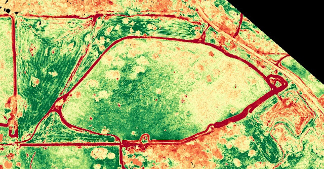
Using Drone Deploy's 'Plant Health' feature, we were quickly able to visualise the crop health of the oats in four regions, based on the RGB imagery using the VARI algorithm. Each region had an 'area' placed around it to help identify and accurately measure.

Gidgegannup Drone Scan Crop Health Monitoring using Drone Deploy

Zooming in on each of the zones it was easy to see the areas where the crop was struggling and where it was thriving. Being able to see areas of possible trouble is a huge plus for this farmer in accurately monitoring and assessing the crop.

Gidgegannup Drone Scan Crop Health Monitoring using Drone Deploy

Understanding the history to each zone was critical, the zone below was seeded the same day that the rest of the zones, however it is clearly not doing as well.  There are many reasons that could caused such a difference, poor seeding practices, lack of nutrient or water. The imagery is only giving an indication that there is a problem, it cannot diagnose (yet) what the problem is, this is where ground truthing is always recommended.

Gidgegannup Drone Scan Crop Health Monitoring using Drone Deploy

Using the 'Zones' tool we can simplify the 'health rating', this in turn can create a 'Grid' which can then be as a prescription chart for variable spraying of fertilisers etc


Gidgegannup Drone Scan Crop Health Monitoring using Drone Deploy

Gidgegannup Drone Scan Crop Health Monitoring using Drone Deploy

The above is an analysis based on RGB imagery, however using an NIR filtered camera would produce more accurate results using the NDVI algorithm. With this more detailed analysis too it's possible to calculate crop biomass, nitrogen deficiency, disease, drought, pest infestation, salinity, and more. Understanding this can save a farmer money because it enables them to apply fertilizers, pesticides, and herbicides only when and where they are needed.

This has been another 'drone adventure' in aerial surveying, inspection and mapping by The Aero Scout.

Quarry and housing development - 3D drone map


Drone mapping a quarry and new housing development

Mission Summary

  • Goal:  To create a 'drone map' of a quarry and housing development
  • Tech: Skyray fixed wing drone, Canon S100 camera, Tower app, Drone Deploy
  • Conditions: Midday, sunny, nil wind
  • Outcome: 50 hectares where successfully mapped in 14min. :)

I found an excellent site that was going to allow me to demonstrate how a drone map can assist both a quarry manager and a housing development manager with planning and monitoring of the site.

2D map of the quarry (left) and new housing development (right) created with drone images
Elevation visualisation of the quarry and housing development

3D view of the quarry and new housing development
This has been another 'drone adventure' in aerial surveying, inspection and mapping by The Aero Scout.