Slider

slide1

Drone Structure Scan - Derelict Cottage

Detailed 3D model of and old derelict cottage in Midvale.

slide2

Small Drone Mapping 101

The Aero Scout shares his experiences with drone mapping and 3D models.

slide3

Arthur River Mt Pleasant Kitchen - 3D drone structure scan

3D model of the heritage building Mt Pleasant Kitchen in Arthur River.

slide4

Chestnut Brae - Farm planning map in Nannup

Demonstrating how drone imagery can be used as a base for effective farm planning.

slide5

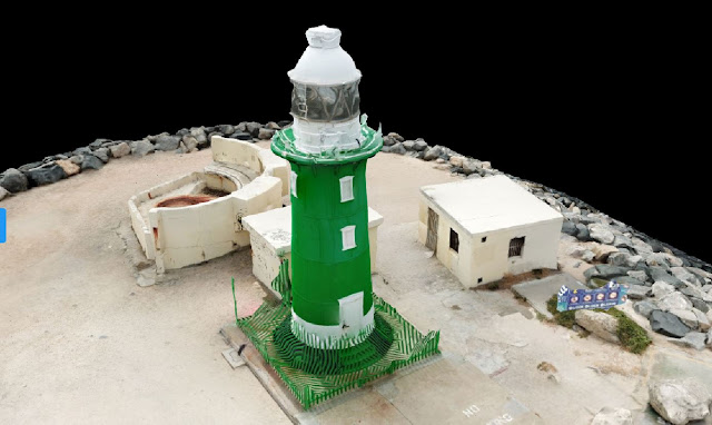
Drone Structure Scan - Heritage Lighthouse

Drone structure scan of the heritage South Mole Lighthouse in Fremantle.

Point King Albany WW II Observation Post


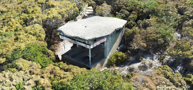
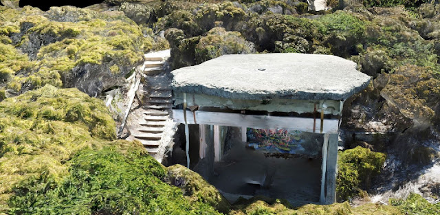
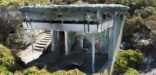
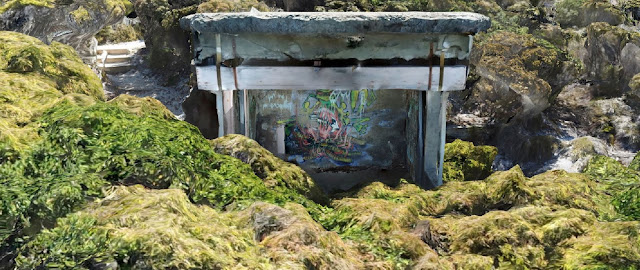
Point King, Albany WW II Observation Post Drone Scan with Drone Deploy
Drone scan of  an un-named WWII observation post near Point King, Albany, Western Australia

Drone Structure Scan - Historical Landmark

Drone Structure Scan of a WW II Observation Post at Point King, Albany using a Mavic Pro and photogrammetry processing with Drone Deploy.

Mission Summary

  • Goal: To create a highly detailed drone structure scan of a WWII observation post that reminded me of the Autodesk Recap video of Battery Townley near San Francisco.
  • Tech: DJI Mavic Pro, Drone Deploy
  • Conditions: Midday, sunny, very windy
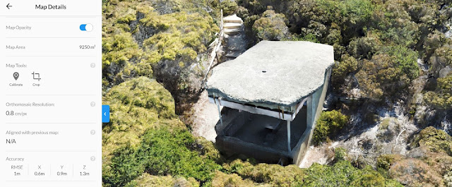
  • Outcome: This ended up being my most detailed map to date. See above the 'map details'  show a resolution of 0.8cm/px and an RMSE of 1m. This was accomplished with a fully manual flight (no automated flight plan), in very windy conditions and using a Mavic Pro with a 12Mp camera. I'm impressed and super proud. :)
Point King, Albany WW II Observation Post - Drone Scan Image-1
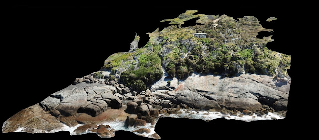
The entire site, flown very carefully manually with the camera set to take a photo every 2sec

Point King, Albany WW II Observation Post - Drone Scan Image-2
A glimpse of the old WWII concrete structure just visible amongst the thick coastal scrub

Point King, Albany WW II Observation Post - Drone Scan Image-3
The roof of the structure was created in a 'ragged' form to make it look like a rock

Point King, Albany WW II Observation Post - Drone Scan Image-4
The detail of the structure scan created by Drone Deploy was excellent, this is my best scan to date

Point King, Albany WW II Observation Post - Drone Scan Image-5
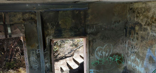
A detailed look inside the structure, this was made possible by the upward camera option on the DJI Mavic Pro

Point King, Albany WW II Observation Post - Drone Scan Image-6
Flying the DJI Mavic Pro manually and very close to the structure meant I could capture detailed photos of it's interior 

Point King, Albany WW II Observation Post - Drone Scan Image-7
Using the upward camera feature of the DJI Mavic Pro I managed to capture all of the inside of the structure, including it's soffit
Point King, Albany WW II Observation Post - Drone Scan Image-8
Some of the graffiti tags over the structure

Point King, Albany WW II Observation Post - Drone Scan Image-9
Elevation gradient of the site, clearly showing the rocks, dense scrub and access to the structure
Drone Deploy Logo

A link to the Autodesk video that inspired it all;  From GoPro photos to a conceptual model in Revit. In 2014, when I watched this video I was hooked, it gave me the initial spark and motivation that got me interested in drone scanning and Scan-To-BIM technology and methodologies. Since then it has been both a passion and addiction to drone-scan nearly everything that I see.

If you liked this post, check out another similar post on a scan I did on the same road trip, it's of the Arthur River Mt Pleasant Kitchen heritage cottage.

This has been another 'drone adventure' in aerial surveying, inspection and mapping by The Aero Scout.

Arthur River Mt Pleasant Kitchen Cottage

Arthur River Mt Pleasant Kitchen Drone Scan with Drone Deploy - Image 1
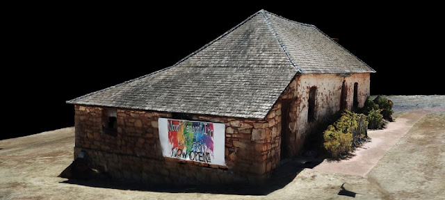
Drone scan of the Arthur River Mt Pleasant Kitchen built in 1869 to cater for travellers, sandalwood cutters and settlers

Drone Structure Scan - Heritage Cottage

Drone Structure Scan of the heritage building Mt Pleasant Kitchen in Arthur River, Western Australia using a Mavic Pro and photogrammetry processing with Drone Deploy.

Mission Summary

  • Goal: To drone scan a heritage cottage and capture the details under the veranda
  • Tech: DJI Mavic Pro, Drone Deploy
  • Conditions: Midday, sunny, moderate wind, extremely hot (45 degrees celcius)
  • Outcome: On a stinking hot day I used three/four orbit rings plus some handheld pics under the veranda to create one of my best scans yet. The detail under the veranda and the eaves would not have possible without the 'camera angled up' feature on the Mavic Pro.  

Arthur River Mt Pleasant Kitchen Drone Scan with Drone Deploy - Image 2
The stats from Drone Deploy show the resolution and accuracy of the scan

Arthur River Mt Pleasant Kitchen Drone Scan with Drone Deploy - Image 3
Even the plants are looking great in the scan. Also see the accuracy under the veranda 

Arthur River Mt Pleasant Kitchen Drone Scan with Drone Deploy - Image 4
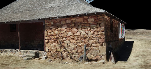
This image shows the level of detail captured under the veranda

Arthur River Mt Pleasant Kitchen Drone Scan with Drone Deploy - Image 5
Beautiful stonework captured in a virtual 3D model

Arthur River Mt Pleasant Kitchen Drone Scan with Drone Deploy - Image 6
The textures in the model are great and the detail in the sign creates a real point of interest
Drone Deploy Logo

If you liked this post, check out another similar post on a scan I did on the same road trip, it's of the Point King Albany WWII Observation Post.

This has been another 'drone adventure' in aerial surveying, inspection and mapping by The Aero Scout.

Gooseberry Hill National Park


Gooseberry Hill National Park Drone Scan with Drone Deploy - Image 1
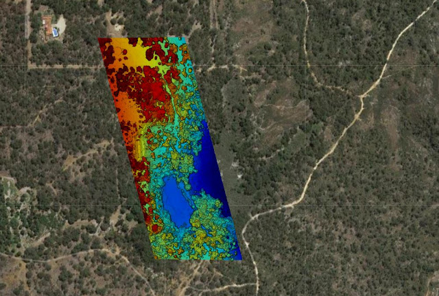
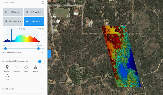
Elevation map showing clearly showing the gradient of the underlying terrain 

Drone Site Scan - Through Heavy Vegetation

Drone site scan of a heavily wooded area in Gooseberry Hill, Western Australia.

Mission Summary

  • Goal: To determine the gradient of the terrain in a densely wooded area
  • Tech: DJI Mavic Pro, Drone Deploy
  • Conditions: Morning, sunny, light wind
  • Outcome: The imagery was successful in penetrating the canopy and offering valuable insights into the topography of the area of interest  
Gooseberry Hill National Park Drone Scan with Drone Deploy - Image 2
The high resolution imagery taken from the drone scan is clearly visible next to the satellite imagery


Gooseberry Hill National Park Drone Scan with Drone Deploy - Image 3
Colour elevation gradient produced via Drone Deploy
Drone Deploy Logo

This has been another 'drone adventure' in aerial surveying, inspection and mapping by The Aero Scout.

Kulin Water Slide

Kulin Water Slide Drone Site Scan with Drone Deploy - Image 1
3D model of the Kulin water slide created using drone images

Drone Site Scan - Public Infrastructure

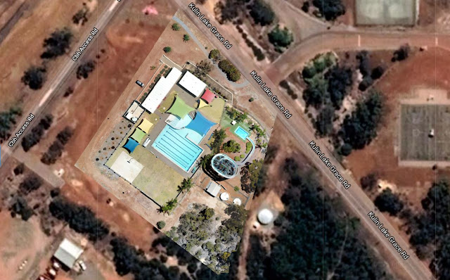
Drone site scan of the famous Kulin Water Slide using a Mavic Pro and photogrammetry processing with Drone Deploy.

Mission Summary

  • Goal: To demonstrate the effectiveness of a drone site scan of public infrastructure for marketing or asset monitoring purposes.
  • Tech: DJI Mavic Pro, Drone Deploy
  • Conditions: Late morning, sunny, moderate wind
  • Outcome: Whilst it was a warm day and upon takeoff the drone was swarmed by 100 pink and grey galahs we managed to site scan the Kulin pool and water slide before any patrons arrived.
    Note: Permission from the Pool Manager was granted for the drone scan
Kulin Water Slide Drone Site Scan using Drone Deploy - Image 2
High resolution plan view of the Kulin water slide using drone images
Drone Deploy Logo

This has been another 'drone adventure' in aerial surveying, inspection and mapping by The Aero Scout.

West Kulin Tin Horse Highway

West Kulin Tin Horse Highway Drone Scan using Drone Deploy - Image 1
3D drone scan of the West Kulin Whoppa tin horse

Drone Structure Scan - Tin Horse

A drone structure scan of part of the West Kulin Tin Horse Highway using a Mavic Pro and photogrammetry processing with Drone Deploy.

Mission Summary

  • Goal: To drone scan a couple of the famous Kulin tin horses.
  • Tech: DJI Mavic Pro, Drone Deploy
  • Conditions: Late afternoon, sunny, moderate wind
West Kulin Tin Horse Highway Drone Scan using Drone Deploy - Image 2
3D drone scan of one of the West Kulin Tin Horses
Drone Deploy Logo

This has been another 'drone adventure' in aerial surveying, inspection and mapping by The Aero Scout.

Graffiti Train Carriage

Drone scan train carriage Leighton Beach using Drone Deploy - Image 1
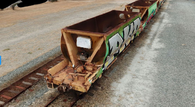
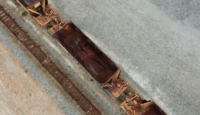
Drone scan of a couple of railway carriages with graffiti painted on their sides

Drone Structure Scan - Graffiti Train Carriage

Drone Structure Scan of a train carriage at Leighton Beach, Perth using a Mavic Pro and photogrammetry processing with Drone Deploy.

Mission Summary

  • Tech: DJI Mavic Pro, Drone Deploy
  • Conditions: Midday, overcast, moderate wind
  • Comments: I spotted an interesting subject matter for a drone inspection scan next to the beach we frequent. 
Drone scan train carriage Leighton Beach using Drone Deploy
The ends of each carriage has a small framed area, this was the biggest challenge for the software

Drone scan train carriage Leighton Beach using Drone Deploy
The chute at the base of each carriage did not model well, next time I'll take more nadir images 

Drone scan train carriage Leighton Beach using Drone Deploy
The graffiti images rendered extremely well using Drone Deploy processing
Drone Deploy Logo

This has been another 'drone adventure' in aerial surveying, inspection and mapping by The Aero Scout.

South Mole Lighthouse

South Mole Lighthouse Fremantle Drone Scan using Drone Deploy - Image 1
3D model of the Fremantle South Mole lighthouse created using drone images

Drone Structure Scan - Heritage Lighthouse

Drone structure scan of the heritage South Mole Lighthouse in Fremantle, Western Australia using a Mavic Pro and photogrammetry processing with Drone Deploy.

Mission Summary

  • Goal: To create a digital virtual twin of the Fremantle South Mole lighthouse using Mavic Pro and Drone Deploy technologies.
  • Tech: DJI Mavic Pro, Drone Deploy
  • Conditions: Midday, overcast, high wind
  • Outcome: Despite the many challenges; high wind, busy light aircraft corridor, having to land twice because of helipad activity this was a very rewarding drone flight and scan. 
South Mole Lighthouse Fremantle Drone Scan using Drone Deploy - Image 2
Designed by C.Y. O''Connor and built in 1903 

South Mole Lighthouse Fremantle Drone Scan using Drone Deploy - Image 3
A clear view of the old gun defences erected during WWII next to the lighthouse

South Mole Lighthouse Fremantle Drone Scan using Drone Deploy - Image 4
Spot the sign hanging in mid-air. :)
Drone Deploy Logo

This has been another 'drone adventure' in aerial surveying, inspection and mapping by The Aero Scout.